
UNDERSTANDING WATER · READING STRUCTURE
When Does a Drop-Off Really Become Worth Fishing?
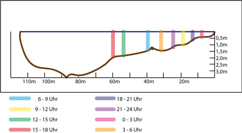
What Is an Underwater Drop-Off?
On a map, you can usually identify a depth break by closely spaced contour lines. In practice, it is wider than a line: the top edge, the slope, and the base of the drop-off. There are often other transitions as well: from hard to soft bottom, weeds to open water, murky to clear water, current to slack water, or light to shade.
In fishing, “drop-off” quickly becomes shorthand for a hotspot. That is too simplistic. A steep drop in a barren basin with little forage may have little to offer. In contrast, a gradual, barely noticeable break can be productive if baitfish are holding along the shallow edge, deep water at the base provides a retreat, and current or wind carries food along it.
That is why you should read more than the bottom's slope. You are reading a connection. Ask about every piece of structure: What can a fish eat here, where can it conserve energy, and where can it retreat?
Why Do Fish Use Transitions Instead of Random Areas?
Forage fish are not distributed evenly by chance. They seek cover, suitable temperatures, oxygen, food, or current that does not constantly drain their energy. Predators do not simply follow the deepest water; they use places where they expect prey and can control their position. A drop-off can bring these needs together.
A perch may follow a school of baitfish over a drop-off, hold at the edge of the school, or use the transition to deeper water. A pike may wait along a vegetation edge if the drop-off connects a shallow feeding area with deeper water for shelter. A zander in a river may use the edge of a channel or a current seam if it does not have to constantly fight the main current there. So the drop-off is not the destination—it is a potential route between two habitats.
The season changes this function. In spring, shallow water, emerging forage, and rapidly warming temperatures can be productive. In summer, the transition to a deeper, cooler zone may become more important. In fall, forage often moves differently, and a long flat or a drop-off into a deeper basin may become a search route. General depth recommendations are less useful than observing where the forage is now.
Which Drop-Offs Should You Check First?
- Shallow water plus depth: The mouth of a bay, a shallow flat, or a weed edge with immediate access to deep water can connect feeding and shelter areas.
- Drop-off plus forage: If you see baitfish, surface activity, or relevant fish finder returns, do not fish only through the school. Check its edge, the drop-off below it, and the escape route to the side.
- Drop-off plus wind or current: Wind can move food and murky water; current can deliver food. The most interesting area is often where fish benefit from it without expending too much energy.
- Drop-off plus cover: Weeds, submerged wood, rock, a mussel bed, or a hard-bottom transition give the bottom contour an additional function.
- Drop-off as part of a route: A long drop-off is not a single GPS position. Mark its beginning, middle, end, and connection to the next type of structure.
On unfamiliar waters, simple prioritization helps: Do not look for the steepest line, but for two or three drop-offs that are promising for different reasons. Then you can compare them. Do you get bites only along the windblown weed edge? Only at the base of the drop-off? Only where the channel enters a bay? After a few focused sessions, this builds knowledge of the water instead of merely collecting spots.
How Do You Fish a Drop-Off Without Skipping the Key Zone?
Many casts cross a drop-off so quickly that the lure barely stays at the productive depth. From shore, a cast parallel to the drop-off can keep the lure in the strike zone longer. A diagonal cast tests the slope. A cast across the drop-off shows whether the bite comes at the top edge, on the fall, or at the base. From a boat, you can also plan your drift or direction of travel so that the depth changes in a controlled way.
Start with a clear question: Is the forage above the drop-off, directly on the transition, or just off the base? Do not merely let the lure fall toward the bottom. Work it at the suspected depth. With a soft plastic, a small, controlled lift can be useful: Raise the rod tip, take in a few centimeters of line, and let the lure sink back into the same zone. Jumps that are too large or a jighead that is too heavy can quickly pull it out of the relevant window.
The lure is the measuring tool, not the main idea. If you feel only soft mud on the bottom, hard contact on the slope, or weeds at the top edge, you are learning the contour. Keep the casting direction, depth, and retrieve consistent enough for each contact to have meaning.
How Do You Read Drop-Offs in a Lake or Gravel Pit?
A gravel pit often has distinct, steep drops. That makes the map appealing but can lead to a mistake: Everyone fishes the same visible drop-off. It is better to read its path. Where does it become more gradual? Where does it curve into a bay? Where is there a small ledge, weed bed, or flat in front of it? These irregularities create more opportunities than an endlessly uniform wall.
In clear lakes, light, the thermocline, and water clarity can change the relevant depth. The thermocline explains why a contour line alone is not enough in summer. For perch, the seasonal pattern adds context to the map: Where Do Perch Hold Throughout the Year?
How Are River Drop-Offs Different?
In a river, a drop-off can form the boundary between the deep main channel and a shallower shoreline area. It can also lie at the tip of a groyne, along an eddy, at a riprap bank, or on an outside bend. Water level and current change its function: During high water, other areas become accessible; during low water, movement is often concentrated more strongly around channels and transitions.
Therefore, you should never rely solely on depth in a river. Observe the current seam, foam, drifting material, inflow, and outflow. The in-depth article River Zander: Shorelines, Drop-Offs, and Current uses your original material to show how this becomes a practical search strategy.
Which Mistakes Make a Good Drop-Off Worthless?
- “Steep automatically means good.” No. The drop-off needs a function and a connection.
- “The number on the map is exact.” Maps may be incomplete, outdated, or calculated between survey points. Check the actual conditions.
- “I fished the drop-off.” A single cast across the slope does not test the top edge, base, and lateral path.
- “No bite means I need a different lure.” First, check your position, depth, and casting angle.
- “Yesterday's catch proves this is a good spot.” Record the conditions. That is the only way to recognize when and why the same drop-off works again.
What Does Your Drop-Off Plan Look Like Before the First Cast?
- Determine the shape: A map, shoreline, fish finder, or depth sounding reveals the top edge, slope, base, and path.
- Find the connection: What is nearby: weeds, a bay, channel, flat, inflow, current seam, or open water?
- Check current conditions: Assess the wind, water level, visibility, temperature trend, and season.
- Observe forage: Baitfish and activity tell you more than an attractive section of a map.
- Fish each area separately: Test the top edge, slope, base, and side with deliberate angles and depths.
- Record the result: Note not only the catch, but also the conditions and the exact function of the drop-off.
A drop-off is not a point on the map that you can check off. It is a question for the water: Which connection is valuable to my target species here right now? If you answer this question before choosing the lure, you will waste less time on contours that may look spectacular but explain nothing today.
Sources and adaptation: This article brings together the existing map logic, target-species articles, and the original map from the river zander article. The graphic serves as a specific example of a river transition; the transferable logic for lakes and rivers is deliberately presented separately.