
Understanding Waters · Lake
How Do You Find the Thermocline in a Lake—and What Does It Mean for the Fish?
What Is a Thermocline in a Lake?
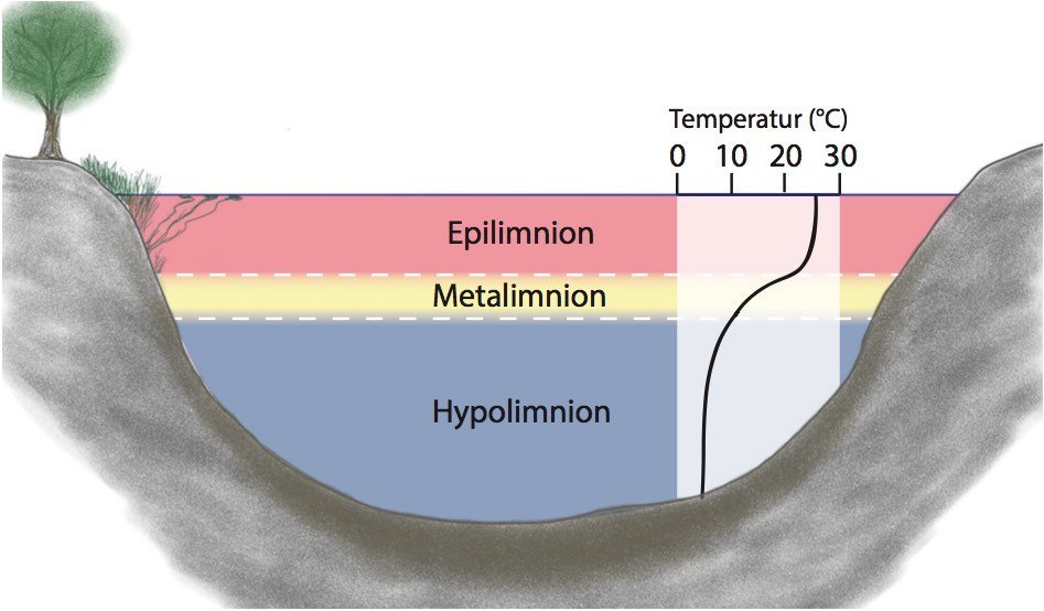
In summer, a deeper lake can be divided into three zones: the epilimnion at the top, the warm layer that is more affected by wind; the metalimnion in the middle, the thermocline; and the hypolimnion below, the colder deep water. The temperature changes especially sharply in the metalimnion. How distinct the boundary is and how deep it lies depend on the weather, wind, lake depth, water color, and time of year.
This matters to anglers because temperature affects the behavior of fish, prey, and plants. But the thermocline is not an invisible fence. Some fish cross it, some use the area near it, and others stay in a completely different zone. It is therefore a clue for your search, not a definitive answer to where you should cast.
How Does the Thermocline Form?
Water reaches its highest density at about four degrees Celsius. In spring, a lake may still mix extensively after winter, with relatively similar temperatures and oxygen levels at many depths. As warming continues, a less dense, warm layer forms at the surface. It lies like a lid over the colder water below. Wind mainly mixes the upper water layer but does not always reach the deep water.
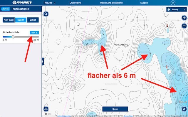
There is no fixed rule such as “the thermocline starts at seven meters.” Shallow, wind-exposed waters may mix all the way to the bottom. Deeper, sheltered lakes may develop more distinct stratification. The pattern also changes after prolonged wind, a cold snap, or as fall approaches. Never use depth without context.
When Does the Thermocline Occur Throughout the Year?
Spring Turnover
After winter, the water warms and can mix throughout much of the water column. This distributes oxygen and nutrients differently than in midsummer. For choosing a location, this means fish are not automatically restricted by a strong thermal barrier. Shallow water, warming bays, spawning areas, and feeding areas may then be more important than a supposed depth rule.
Summer Stagnation
During extended warm periods, stratification can stabilize. It is then worthwhile to examine the transition zone particularly closely. Prey may gather along temperature, light, or food boundaries, and predators may take advantage of this proximity. Whether that happens above, within, or just below the thermocline, however, depends on oxygen levels and the specific fish.
Fall Turnover and Winter
As surface water cools, the difference between the upper and lower layers decreases. Wind can mix the lake more thoroughly again. This can make deeper areas accessible to some fish in different ways. Under ice, the coldest water is at the top, with denser water around four degrees deeper down. Oxygen and prey still deserve attention—but the summer thermocline is no longer an appropriate model.
Can Fish Stay Below the Thermocline?
Temperature and oxygen are related, but they are not the same thing. Warm water can hold less dissolved oxygen than cold water. At the same time, oxygen enters the water through the surface, wind, and plants, while decomposition of organic material consumes it near the bottom. As a result, a nutrient-rich lake may have problematic oxygen levels below the stratified layers in midsummer, while a clear, deep lake may still provide suitable habitat there.
This is the most important correction to the myth that “there are no fish below the thermocline.” Without measurements, you do not know whether the deeper zone is habitable. Even when oxygen is low, individual fish may briefly stay deeper or pass through. For your fishing plan, this means treating the layer as a boundary you need to evaluate, not a no-entry sign.
If a lake's near-surface water is very warm in summer and its deeper water has little oxygen, the usable area for fish can shrink dramatically. That is precisely when it is especially valuable to assess prey, temperature, and oxygen together instead of simply heading for the deepest point on the map.
How Do You Find the Thermocline on the Water or With a Fish Finder?
You cannot reliably see the thermocline from shore. The season, lake depth, recent weather, and observations of prey provide clues. From a boat, a depth thermometer, fish finder, and repeated measurements help: If the temperature drops significantly over just a few meters, you have solid evidence of the transition zone. Record the time, wind, and location—a sheltered bay may look different from the open middle of the lake.
On a fish finder, the thermocline may appear as a diffuse band because suspended particles or plankton are concentrated there. This can be very helpful, but it must not be mistaken for a school of fish. Calibrate the display and sensitivity, observe whether the band remains stable over several passes, and check whether baitfish signals are above, within, or below it.
Which Fish and Baitfish May Be Found Near the Thermocline?
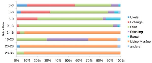
In a suitable lake, the transition zone may combine cover, concentrations of food, and a more comfortable temperature range. Large northern pike may use the cooler layer nearby in summer; yellow perch or zander do not automatically follow the same depth. A school of perch may stay higher above a drop-off, while a zander uses a transition below it. The target-species article therefore always complements the model of the body of water: northern pike, yellow perch, and zander.
Prey is your anchor. If you find baitfish above the thermocline, do not fish only through the middle of the school. Check the edge below it, the area beside the prey, and the direction it is moving. Predators may follow the school, cut it off from the side, or use a deeper refuge nearby.
How Do You Turn This Into a Fishing Plan?
- Classify the water: deep or shallow, clear or murky, stratified or mixed?
- Check the transition zone: Do not assess the temperature profile and fish finder at only one location.
- Locate prey: Observe the depth, edges, and movement of the baitfish.
- Connect it to structure: Look for a drop-off, flat, weedline, or channel edge at that depth.
- Fish three levels: just above, within, and below the likely zone—provided it appears habitable.
- Record the result: Temperature, wind, depth, prey, and strikes will help more on your next visit than a new lure color.
The thermocline does not help you find a secret depth. It helps you eliminate large amounts of water faster and ask better questions: Where is the prey accessible today, and what structure gives my target fish an advantage there?
Sources and adaptation: This article expands on the existing WordPress post about the thermocline and retains its three original graphics. The statements were deliberately made more precise: The thermocline and oxygen are considered separately, while depth, oxygen, and fish location depend on the body of water and weather. It complements the Understanding Waters topic overview and links to the respective target-species articles.