
Zander Fishing · Rivers
How Far From Shore Are Zander in Rivers—and Where Are Their Hotspots?
Why Is Every Zander River Different?
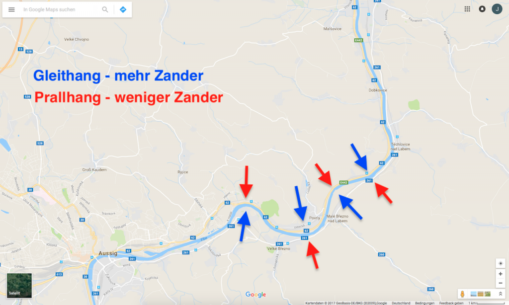
In a river, the water is moving. This determines where prey can hold and how much energy a zander must expend to maintain its position. The main current carries food, but it is not a suitable resting place everywhere. Transitions become interesting: the edge of a slower current lane, the tailout of an eddy, the edge of a deep channel, an underwater point, or a hard bottom transition.
The river also changes with the water level. At high water, slack-water pockets, flooded shorelines, or side channels may become accessible. At low water, current and prey become concentrated around channels, drop-offs, and outlets. A familiar groyne head is therefore not a permanent formula. Record the water level, turbidity, current direction, and prey-fish observations instead of merely noting, “Groyne 17 produced.”
Temperature also behaves differently than in a lake. Water is mixed more thoroughly in the main current, although shallow harbors, bays, and side channels can still warm or cool differently. Zander do not seek “the river,” but rather a zone where prey, cover, visibility, and energy expenditure align at that moment.
What Does the Elbe Telemetry Study Show About Zander in Rivers?
Horký, Slavík, and Bartoš tracked eight zander for twelve months along an approximately 40 km section of the Elbe near the German border. The fish were located weekly; to study daily cycles, the team recorded positions during eight consecutive three-hour intervals. The regulated stretch was 60 to 140 m wide and up to about four meters deep. This makes the study unusually valuable: It describes repeated locations in a real river, rather than a snapshot of a fish that was caught.
The authors found that the fish were in the deeper main current during the day, moved into shallower water at twilight, and were closest to shore at night. Activity was highest at twilight and lowest at night. This corrects a common assumption: A shallow nighttime position is not automatically a feeding area. In this study, the authors interpret it more as a resting position.
Do not apply the exact distances or times to your river. The studied stretch has its own current, bank reinforcement, and prey. Apply the search logic: Day = check deeper refuge areas; twilight = check shallower feeding edges; night = consider the nearshore area as a possible holding position, but do not blindly treat it as a feeding window. The telemetry study by Horký, Slavík, and Bartoš therefore remains useful context—but not a casting map for another river.
How Far From Shore Were the Zander in the Elbe Study?
Zander No. 35, shown in the old article, was located about 8.7 to 35.5 m from the right bank during the weekly measurements. The observed distances for the other fish were also frequently in the nearshore area, in some cases up to approximately 50 m. That is noteworthy for a river of this width—but it does not make every riprap bank a sure thing. What matters is whether there is actually a drop-off, prey-fish route, or current transition between the bank and the target zone.
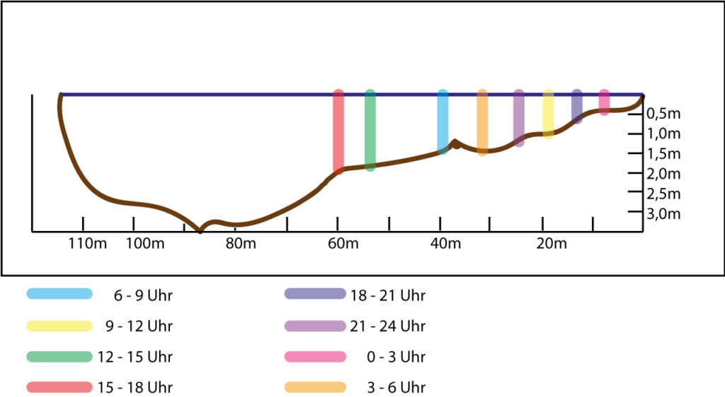
For shore anglers, this is good news: The best area does not have to be in the middle of the river. First check the channel in front of your feet, the first and second drop-offs, the tailout of a groyne, and the current seam. A short, well-controlled cast through the correct depth is better than a maximum-distance cast that pulls the lure past the target.
Where Were the Zander During the Day, at Twilight, and at Night?
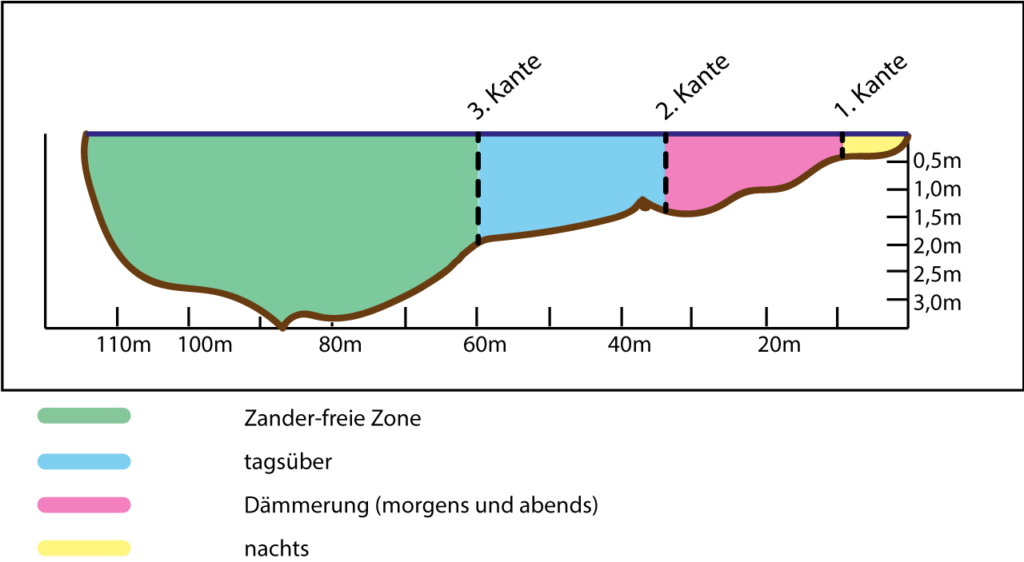
During the day: The study classifies the deeper main current more as a refuge area. Depending on the shoreline shape and channel, a zander may hold within casting range or far offshore. Therefore, do not fish only on the bottom: A lure running just above the bottom or along the drop-off may better target the suspected depth than a jig that jumps far out of the strike zone with every hop.
Dawn and dusk: Activity increased and the fish moved into shallower water. This is when the zone between the first and second drop-offs, the outer edge of a current seam, or a shallower margin next to cover becomes especially plausible. Check for prey and test lure depth there before changing color.
At night: Zander may hold very close to shore and in shallow water. However, the authors interpreted the nighttime positions more as resting than active feeding. In practice, this does not mean “never fish at night,” but rather: Do not automatically infer an active fish from its proximity to shore. Water color, prey, light, and the specific river stretch can alter the pattern.
Which River Structures Are the Best Starting Points?
Groynes and Groyne Fields
A groyne does not create just one hotspot. The upstream side, head, eddy, tailout, and drop-off to the main current have different depths and energy levels. Check these parts separately. Groynes can be heavily pressured; similar features created by a small point, riprap, or a bend in a sheet-pile wall are then often overlooked.
Channels, Scour Holes, and Hard Transitions
Depth is valuable when it provides access to prey. A channel next to shallower, structure-rich water gives zander both a refuge and feeding area. Hard bottom, rocks, gravel, or mussels can also provide food and orientation. A deep hole without prey is only a number on the map.
Harbors, Inflows, and Side Channels
Current, temperature, visibility, and prey can differ here. Often, the key area is not the center of the slack water but the transition through which food moves in or out. Check the access point, drop-off, and outflow—and the local regulations governing harbors, shipping traffic, and protected areas.
What Depth Is a Sensible Starting Point When Fishing for Zander in Rivers?
The Zander Book describes a large river study involving many zander in which a large proportion of the observed fish were at around four to six meters in April and from June through October. This is a useful starting point for comparable rivers, but not a target depth for a three-meter-deep canal or a river at flood stage. In cold periods, with different prey, or at a deep scour hole, the appropriate depth may differ.
Therefore, work outward from the structure: first the drop-off at the suspected prey depth, then the bottom in front of it, and then the water above it. If the lure only brushes the bottom, it may miss a zander holding just above the drop-off. If it runs too high, it leaves the fish's field of view. The correct depth is where your lure crosses the prey and attack line.
How Do You Work a Lure Through the Current?
A lure moves quickly with the current; against it, the lure can rise or create too much resistance. A diagonal cast across a seam often keeps it along the drop-off longer. The right angle depends on the depth and obstacles. Before casting, plan a specific section: “This is where the lure should run at a consistent depth along the channel.”
In the main current, a more active presentation can make sense because prey is also moving. In a slack-water zone or along a deep drop-off, subtle lifts may work better: Raise the rod tip only slightly, move the lure a few centimeters, and let it sink again in the same zone. A heavier jighead maintains contact, but can make the lure jump out of the strike zone too quickly. A lighter head moves more naturally, but requires more control in wind and current pressure.
For a more in-depth guide to retrieving, jigging, and subtle lifting, see the article Zander Fishing With Soft Plastic Lures.
How Do You Fish a River Stretch Systematically?
- Read the water: Check the water level, current direction, turbidity, and safety before the first cast.
- Map the current: Mark the main flow, seam, eddy, tailout, and drop-off.
- Find prey: Watch for surface activity, small fish, sonar returns, and food entering the water.
- Fish three depths: Deliberately test the bottom, drop-off depth, and slightly above it.
- Change angles: Cast upstream, diagonally, and downstream only when the lure passes through the target area under control.
- Change one variable: Start with depth or angle, then presentation, and finally lure shape or contrast.
- Keep records: Record the time, water level, wind, contact, and exact position.
The best river spot is not found on a list. It is the area where you can explain where the prey moves, how zander conserve energy, and what path your lure takes through that zone. The right question is: Which drop-off here connects the deeper refuge area with the shallower feeding zone?