
Carp fishing · Understanding rivers
Carp Fishing in Rivers: Where Do Carp Hold in Current?
How do you read a carp river?
A lake allows many carp to use large areas without constantly expending energy. In a river, that equation changes. Water moves, carries food, reshapes the bottom, and can make entire shoreline areas unusable during high water. A spot that was calm yesterday may be under pressure tomorrow. That is why water level is not a minor consideration, but part of the location itself.
Start with the big-picture map: Where are the bends, side channels, groyne fields, inflows, oxbows, bridge areas, scour holes, and overhanging trees? Then assess the section from the bank. Read the current by watching drifting material, eddy lines, smoother water, bubbles, foam, and movement along the edge. A seemingly unremarkable area behind woody debris can be more valuable to a carp than the visible main current.
Therefore, ask yourself four questions: Where can a carp hold comfortably? Where does food drift past or lie on the bottom? Where does it find cover? And what route can it take between these functional areas? Only once you see this connection is it worth considering the details of the rig, feeding spot, or bait.
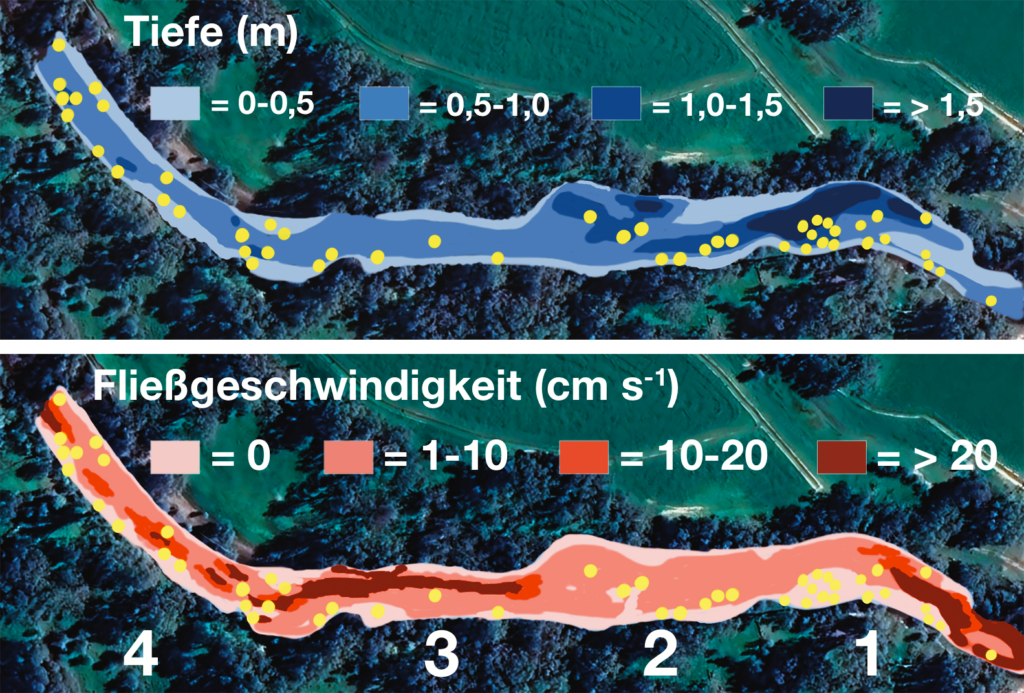
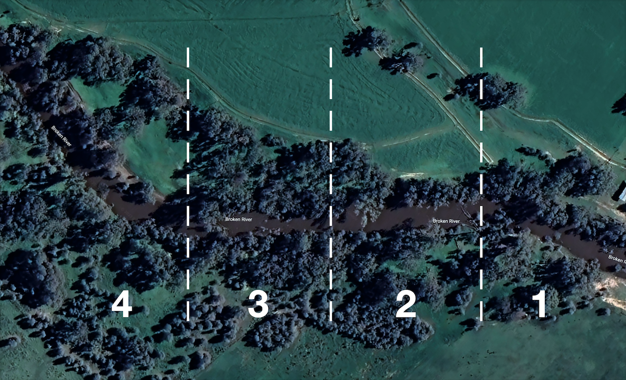
What does the Broken River study show about carp locations?
The original article draws on the 2002 doctoral thesis by David A. Crook. The study examined a lowland section of the Broken River in southeastern Australia. Carp and their positions were assessed in relation to depth, current velocity, bottom composition, and cover. This alone establishes the most important limitation: It concerns a specific body of water, a specific water condition, and a population of introduced carp—not universal instructions.
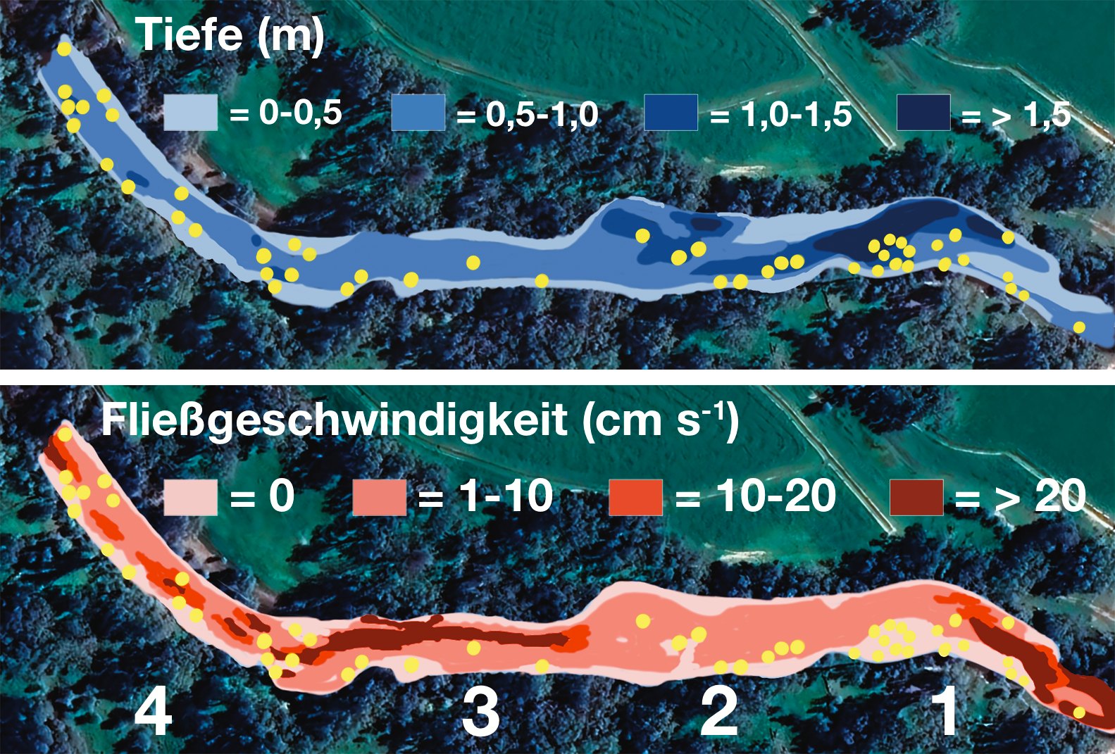
In the nighttime survey, several readings were located in deeper areas or sections with less current, some close to the bank. This does not mean, “Carp always hold deep and still at night.” It means that in this low-water scenario, energy-efficient areas were relevant. This way of thinking can be applied elsewhere: Determine where carp lose little energy at the current water level without giving up access to food and cover.
The key takeaway is not to consider individual features in isolation. A deep channel without cover may be empty. A slack pocket without food may only be a passageway. A spot becomes productive only when several conditions come together.
Why do carp migrate in rivers yet remain within a home range?
A major misconception is that carp are either migratory or resident fish. In reality, both patterns can occur in succession. High water, spawning season, changes in food, or heavy disturbance can trigger movement. The fish may then remain in a smaller section and move between resting areas, feeding areas, and refuges.
In practice, this means a single blank session does not automatically prove that “there are no carp in this section.” First ask whether the fish have simply moved to another spot within their range. Do not immediately search kilometres away; instead, check the next deep pocket, sheltered bank, inside bend, or feeding edge. Conversely, a productive spot is not necessarily always productive: If the flow increases, that same area may lose its function.
How does water level change carp locations?
At low water, pools, deep channels, and calm bank lines are easy to identify. As flow increases, the picture changes. Reinforced banks, areas behind groynes, overhanging trees, or inflows often have different currents than the middle of the river. Where a side channel or oxbow is open and accessible, it can become a refuge. If it is cut off, it is not currently an option.
Do not rely on intuition about water level; record it. Compare gauge levels, the weather over the past few days, and water color with your catches and observations. After just a few accurate entries, you will have a much clearer picture than ten general tips could provide. The spring article also explains why high flow and temperature should not be assessed separately.
How do you find the right current for carp?
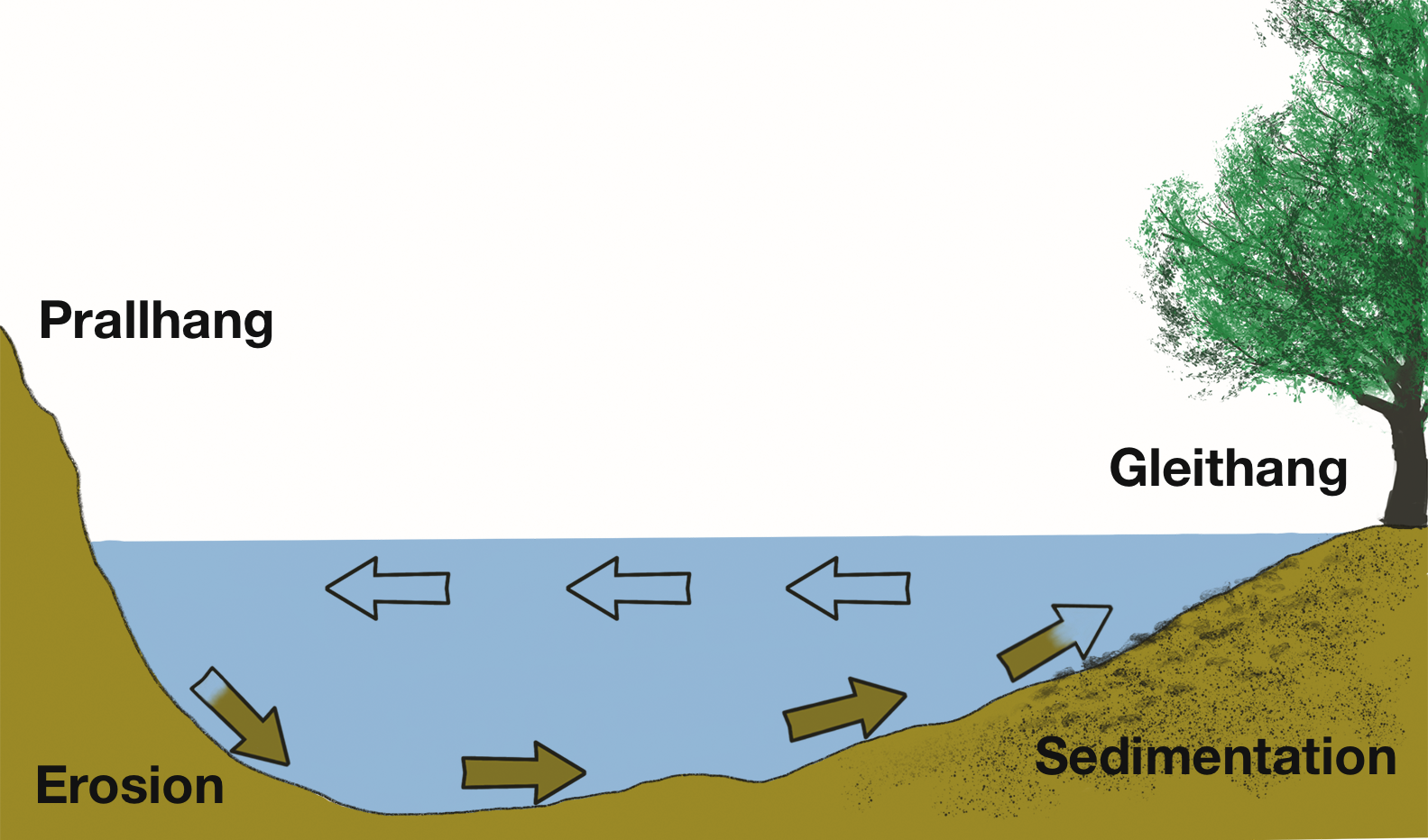
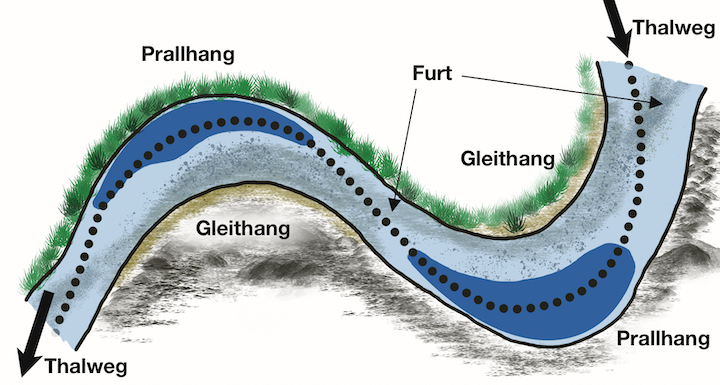
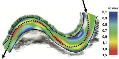
A river bend creates different conditions. At the outer bank, water hits the bank with force, often eroding material and potentially creating depth. At the inner bank, material is more likely to accumulate; shallower and calmer shoreline zones are more likely. Both sides can interest carp, but not for the same reason and not at every water level.
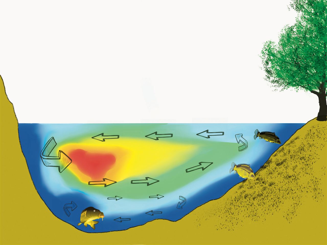
Current also varies throughout the water column. In deeper, sheltered areas, it may be weaker than at the surface. Food carried into the river may also accumulate there. This is a good reason to search along the bottom and edges—not a reason to fish every deep spot blindly.
The thalweg—the continuous deepest line of the riverbed—can provide a reference. However, the best carp spot is not automatically on it. Transitions are especially interesting: the edge of the channel, a deep scour hole beside slower water, woody debris near a food path, or a sheltered bank area with access to deep water.
How do you turn this into a river carp fishing plan?
- Choose a section rather than an individual spot: Mark the main current, slack pockets, deep channels, cover, and accessible side areas.
- Assess the current water level: What has shifted or become inaccessible since your last fishing day?
- Develop a route hypothesis: For example: resting behind structure, food along the edge, and depth as a refuge.
- Change only one variable: If you change spots, do not change the amount of feed and the entire rig at the same time.
- Record observations: Gauge level, time, water temperature, direction of movement, and bites will improve your next fishing day.
The best river spot for carp is rarely the one with the most convenient rod setup. It is the area where you can explain why a carp finds food, protection, and a good route there today. Only then does presentation determine whether that plausible zone produces a bite.
Continue with the carp overview, the article Finding Carp in Spring, and the question of how carp respond to feed.
Source material and image attribution: Further development of the old WordPress article “Carp Fishing on Rivers” and Modern Fish Finding—The Carp. The seven illustrations come from that original article and appear here with their respective topics. David A. Crook's Broken River study (2002) is an Australian case study; its findings are deliberately used as a conceptual model, not as a blanket rule for German rivers.